Key takeaway
The Rail Corridor transformed Singapore’s old Malaysia-Singapore railway line into a continuous 24km green corridor, linking Bukit Timah to Woodlands. It provides space for cycling, walking, and community activities while preserving heritage structures. Managed by NParks and supported by government agencies, the corridor combines conservation, recreation, and urban connectivity, offering residents and visitors a unique linear park that traces the nation’s railway history. Its careful planning ensures safety, accessibility, and ecological preservation, making it a model for urban greenways.
Stretching across Singapore from the northern Woodlands Checkpoint to the city fringes of Tanjong Pagar, the Rail Corridor follows the path of the former Malaysia-Singapore Railway. What was once a transportation artery for trains now serves as a verdant route for walkers, cyclists, and nature enthusiasts. Its conversion balances heritage preservation with public access, creating a continuous green space similar to the Linear Park in Chinatown that threads through urban and suburban landscapes. Along the way, visitors can experience both quiet forested areas and lively communal spots, making each visit unique.
History of the Malaysia-Singapore Railway
The corridor originated from the 1903 railway line connecting Singapore to Malaysia. Initially constructed to transport goods and passengers, it shaped settlements along its path and influenced the growth of surrounding neighborhoods. After the Tanjong Pagar railway station closure in 2011, the 24km stretch from Woodlands to Bukit Timah remained largely disused, overgrown, and inaccessible in parts. Community groups advocated for its reuse as public space, highlighting the historical value and potential for recreational adaptation similar to the way Singapore’s largest park integrates heritage and greenery. Government agencies collaborated with urban planners to preserve significant structures while opening the corridor for public enjoyment.
Route Highlights and Key Areas
The corridor spans multiple planning areas, including Woodlands, Bukit Panjang, Bukit Timah, Queenstown, and Bukit Merah. Along its path, users encounter conserved railway bridges, former stations, and lush vegetation. Certain sections are accessible from nearby MRT stations, making it easy for commuters and visitors to enjoy short walks or long rides along the greenway, reminiscent of nature along MacRitchie Reservoir. In addition to greenery, small playgrounds, fitness corners, and seating areas allow families and individuals to pause and enjoy the environment.
Conserved Structures Along the Corridor
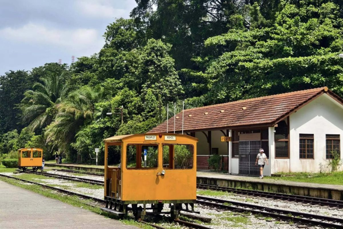
- Bukit Timah Railway Station: Preserved as a historical landmark and community space, the station features heritage signage and a small exhibit showcasing the railway’s history.
- Woodlands Train Checkpoint: Former northern terminal, with interpretive signage for visitors and a viewing area overlooking the tracks.
- Railway Bridges: Restored and reinforced to allow safe pedestrian and cycling passage while maintaining original design elements.
How the Rail Corridor Connects Communities
The corridor links residential estates, parks, and commercial areas, promoting active lifestyles and social interaction. Cyclists can travel from Bukit Timah to Woodlands without encountering major roads, while walkers enjoy shaded stretches and native flora. The integration of the corridor into the urban environment encourages both exercise and community engagement, creating shared spaces for festivals, clean-up events, and informal meet-ups. Its design prioritizes accessibility for all ages, including ramps and smooth pathways.
Sequence of Access Points
- Woodlands Checkpoint: Northern start point with access paths, seating areas, and parking facilities for visitors.
- Mandai Road: Provides trail entry with informative heritage plaques, bicycle racks, and shaded rest spots.
- Bukit Panjang: Connects to existing park connectors and residential neighborhoods, making short strolls or long rides feasible.
- Bukit Timah Station: Southern end with conserved station building, small park, and interpretive displays about the railway’s history.
Flora and Fauna Along the Greenway
With native trees, shrubs, and wildflowers, the corridor serves as a habitat corridor for birds, insects, and small mammals. NParks monitors biodiversity and encourages visitors to maintain cleanliness. Seasonal changes bring bursts of flowering plants, and morning and evening walks provide opportunities for wildlife observation. Informative signs along the trail explain ecological features, teaching visitors about native species and the importance of urban biodiversity.
Key Buildings Adjacent to the Corridor
| Building | Key facts | Nearest MRT | Sources |
|---|---|---|---|
| Bukit Timah Railway Station | Conserved station building, restored 2013, linear park access with interpretive displays | Downtown Line | – |
| Woodlands Train Checkpoint | Former terminal, adaptive reuse for heritage interpretation, opened 2011, viewing area | North-South Line | – |
| Bukit Panjang Park Connector | Integrated with corridor, maintained 2015, BCA Green Mark Certified, connects residential neighborhoods | Bukit Panjang | – |
Community Engagement and Activities
Local organizations host regular clean-ups, fitness events, guided walks, and educational programs for students. Schools incorporate visits into lessons on nature and history, connecting students to Singapore’s railway heritage. The corridor has become a platform for civic engagement while fostering environmental awareness. Volunteers and community groups contribute to trail maintenance, native planting, and storytelling events, keeping the corridor active and well-cared-for.
Visiting Tips for the Rail Corridor
Whether you are walking, jogging, or cycling, the Rail Corridor offers a mix of history, greenery, and community spaces. To make the most of your visit, it helps to plan ahead and be mindful of both your safety and the preservation of this unique heritage site. Some stretches are quieter, while others are close to residential areas, so plan according to the experience you prefer.
- Wear comfortable shoes and carry water, especially for longer stretches of the corridor.
- Check NParks updates for any temporary closures or maintenance work along the trail.
- Respect heritage structures and do not remove plants, signage, or any artifacts along the route.
- Early mornings or late afternoons offer cooler temperatures and better chances of seeing birds and other wildlife.
- Cyclists should follow trail etiquette, keep a safe speed, and signal when passing pedestrians or other riders.
- Bring a hat or sunscreen if you plan to spend extended time outdoors, as some stretches are exposed to sunlight.
- Consider visiting in small segments if you want to enjoy historical sites and viewpoints without getting too tired.
- Use trail maps and mobile apps for navigation and to find points of interest along the route.
- Bring a camera or sketchbook to capture historic structures and scenic views along the corridor.
Maintaining Heritage While Adding Green Spaces
The Rail Corridor demonstrates how Singapore balances urban development with historical preservation. Adaptive reuse of railway infrastructure preserves character while providing modern recreational amenities. Learn more about sustainable urban planning approaches from green corridors in Singapore to see how such initiatives blend ecology and heritage. The corridor serves as a model for integrating historical assets into city planning.
Walking Through Time Along the Rail Corridor
Strolling from Woodlands to Bukit Timah, visitors witness layers of history embedded in old station buildings, bridges, and tracks. The corridor invites reflection on Singapore’s growth and the evolution of its urban landscape, showing how past infrastructure can be thoughtfully preserved for present use. Every segment offers insight into the nation’s railway heritage, seamlessly integrated into a green corridor that serves the community today. Along the way, walkers and cyclists encounter pockets of lush greenery, shaded resting spots, and interpretive signs that tell stories of the railway’s role in Singapore’s development.
Seasonal changes bring bursts of flowers, shifting foliage colors, and lively bird activity, creating a dynamic experience each time one visits. Community events, from clean-up drives to guided heritage walks, encourage interaction and connection among residents, making the corridor not just a path, but a shared civic space. Whether you are observing dragonflies near streams, hearing the distant chirps of local birds, or simply enjoying the quiet stretches away from traffic, the Rail Corridor offers moments of reflection and discovery. It stands as a living link between Singapore’s past and present, inviting everyone to explore its stories while enjoying nature and community life.